QNH, MOS, and LAMP — How to “Color In” Your XC Weather Picture
Hey guys — Stefan here.
When you’re planning a cross-country, you’re taught (correctly) that METARs and TAFs are the official, legal weather products pilots use.
That’s true.
But here’s the problem most students run into:
METARs and TAFs often give you an outline — but not always a nuanced picture.
That’s where Q-codes (specifically QNH), MOS, and LAMP come in. These don’t replace official weather products — they help you fill in the gaps, add context, and make better planning decisions, especially when your XC goes far beyond your local area.
The Big Picture First
Think of weather products like this:
-
METARs & TAFs → The black-and-white outline (official, authoritative)
-
MOS & LAMP → The coloring that adds depth, trends, and confidence
You still anchor decisions to METARs and TAFs — but MOS and LAMP help you understand what’s likely happening between the lines.
Q-Codes (QNH in Particular)
Why QNH Still Matters for XC Planning
Q-codes are standardized aviation shorthand dating back to early radio and Morse-code operations. Most are historical today, but QNH is still very much alive, especially outside purely civilian U.S. flying.
📚 Source: Skybrary — Q Codes
https://skybrary.aero/articles/q-codes
What QNH Actually Is
QNH is:
The pressure setting that causes an altimeter to indicate altitude above mean sea level (MSL).
In other words:
QNH = international / ICAO-style altimeter setting
It’s not a tool by itself — it’s simply how pressure information is presented in certain forecasts.
One useful way to think about QNH is that it fills in a gap left by standard civilian TAFs. TAFs tell you winds, visibility, and ceilings — but they usually don’t tell you what the pressure will be in the future.
QNH embedded in certain TAFs does exactly that: it adds future barometric context so you can anticipate altimeter setting changes during XC planning.
Why You’ll See QNH in TAFs (Especially Military Airports)
Many military and international TAFs include QNH, sometimes instead of (or in addition to) a standard altimeter setting.
This is extremely useful for XC planning because:
-
QNH is often forecast into the future
-
It may be the only official forward-looking pressure guidance available
-
Civilian METARs rarely provide future pressure trends
👉 When planning a longer XC, finding a future altimeter setting can be surprisingly difficult.
QNH embedded in a TAF often solves that problem.
Example TAFs Including QNH
Example 1 — Military Field (KDMA – Davis–Monthan AFB)
TAF KDMA 061130Z 0612/0718
22008KT 9999 FEW080
QNH2996INS
BECMG 0618/0620 26012KT
TEMPO 0702/0706 5SM -RA BKN040
QNH2989INS
What this gives you for XC planning:
-
Forecast winds and ceilings (standard TAF info)
-
Forecast pressure changes over time
-
Ability to anticipate altimeter setting trends at arrival
Example 2 — International / Joint-Use Style TAF
TAF EGUL 061100Z 0612/0718
18010KT 8000 SCT020
QNH1016
BECMG 0616/0618 21015KT
TEMPO 0700/0704 4000 BR BKN008
QNH1011
Again — QNH provides future pressure context you simply won’t get from METARs alone.
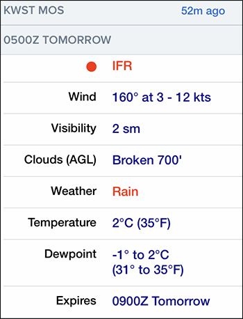
MOS Forecasts
What MOS Is (and What It’s For)
MOS (Model Output Statistics) takes raw weather models and statistically corrects them using years of historical observations.
MOS is not an official regulatory weather product — but it is extremely valuable for planning.
MOS in XC Planning
MOS helps answer questions like:
-
Is this trip even realistic tomorrow?
-
Which alternate airport looks more promising?
-
Are ceilings trending VFR, MVFR, or IFR later in the day?
MOS provides:
-
Winds
-
Visibility
-
Ceiling categories
-
Probability of VFR / MVFR / IFR
-
Temperature & dew point
👉 MOS colors in the future that TAFs only sketch out.
Where to Find MOS in ForeFlight
In ForeFlight, MOS is easy to miss if you don’t know where to look — but it’s incredibly useful once you do.
Typical ForeFlight path:
-
Tap an airport
-
Go to Weather
-
Scroll to MOS
-
View category probabilities and trends over time
This is especially useful when:
-
TAF coverage is limited
-
You’re planning the day before
-
You’re comparing multiple destination or alternate airports
Important MOS Limitations
MOS:
-
Updates less frequently
-
Smooths data
-
Can lag behind fast-changing systems
That’s fine — it’s not meant to replace TAFs, only to support them.
Temperature: Another Little Gap MOS Helps Fill
Here’s an important limitation of TAFs that often goes unnoticed:
TAFs do not forecast temperature.
If you’re planning a cross-country:
-
High density altitude
-
Performance margins
-
Climb capability
-
Takeoff and landing distance
…temperature matters, and METARs only tell you what’s happening now.
MOS helps fill that gap.
MOS provides forecast temperatures and dew points into the future — something you simply won’t find in a TAF.
This makes MOS especially valuable for:
-
Daytime XC planning in summer
-
High-elevation airports
-
Marginal performance scenarios
-
Anticipating density altitude changes later in the day
👉 Just like QNH fills in the future pressure picture, MOS fills in the future temperature picture.
LAMP
What LAMP Is and Who Produces It
LAMP (Localized Aviation MOS Program) is produced by the National Weather Service (NWS) and NOAA.
Its purpose is simple:
Take MOS and make it short-term, reactive, and aware of real-time conditions.
How LAMP “Colors In” the Picture
LAMP blends MOS with:
-
Recent METARs
-
Radar trends
-
Satellite data
-
Short-term model updates
It updates hourly and is best suited for the next 1–6 hours.
Why LAMP Is Gold for XC Decision-Making
LAMP helps answer questions like:
-
Will this ceiling lift before I arrive?
-
Is this MVFR window closing or improving?
-
Should I depart now, delay, or cancel?
👉 LAMP adds motion and trend to the otherwise static snapshot METARs and TAFs provide.
Official LAMP Resource
🔗 NWS LAMP Guidance & Forecasts
https://www.weather.gov/mdl/lamp
This page explains:
-
What LAMP is
-
How it’s generated
-
Where to access airport-specific LAMP forecasts
LAMP Limitations
LAMP:
-
Is not a long-range planner
-
Loses accuracy quickly beyond a few hours
-
Should never replace METARs or TAFs
Putting It All Together for XC Planning
| Product | Role | What It Adds |
|---|---|---|
| METARs | Official observation | What’s happening now |
| TAFs | Official forecast | The basic outline |
| QNH (in TAFs) | Pressure context | Future altimeter insight |
| MOS | Strategic guidance | Big-picture trends |
| LAMP | Tactical guidance | Short-term confidence |
Final Takeaway for Students
METARs and TAFs are required — but they don’t always tell the whole story.
-
MOS and LAMP don’t replace official weather
-
They color in the picture
-
They help you think ahead like a real XC pilot
MOS and LAMP add pressure, temperature, and trend context that official products like METARs and TAFs often don’t include.
If you want to move beyond “legal minimums” and start making smart, confident planning decisions, these tools matter.
—
Stefan
CFI / CFII / MEI
Zulu2992 ✈️